Description
|
Title: |
Oxford Student India Atlas For 3rd Edition |
|
Publisher: |
Oxford University Press |
|
ISBN-10: |
0199450439 |
|
ISBN-13: |
9780199450435 |
|
No. of Pages: |
132 |
|
Published: |
2004 |
|
Edition: |
2015 |
|
Binding: |
Paper back |
|
Language: |
English |
About the Book
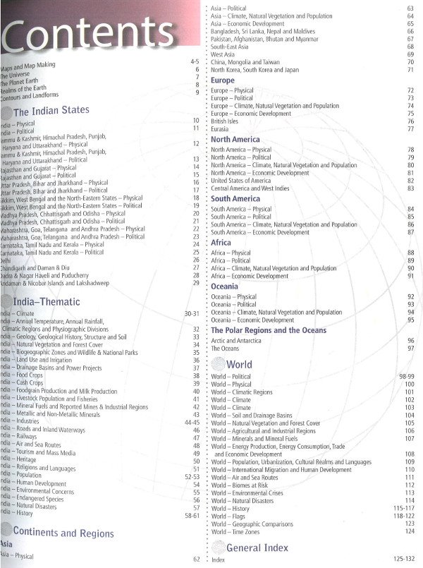
The Oxford Students Atlas for India uses the latest state-of-the-art techniques to produce maps that are accurate and easy to read. Thoroughly researched and up-to-date, this completely new third edition of the atlas is designed keeping in mind syllabi requirements of various education boards in India. It covers India’s physical, geo-political, environmental, demographic, socio- economic, cultural, and historical features with thematic and statistical representation on a range of topics that are usually included in major syllabi. In addition, it vividly traces geographic characteristics of each continent with regional maps of important countries and the world.
Features
- Contains quality digital maps that are aesthetically laid-out and provide up-to-date information
- Uses the latest GIS technology to provide accurate, 3D physical maps and clarify map detail
- Provides the latest available socio-economic maps and data culled from authoritative sources
- Provides special section on the history of map-making, and concepts of contour and landforms in the beginning of the atlas
- Covers important topical themes such as biosphere reserves, wetlands and wildlife. Power projects, agricultural regions, levels of industrial development, human development, tourism and mass media, cultural realms, heritage, etc.
- Includes 24 maps focusing on the history of Indian subcontinent, and 8 maps focusing on environmental concerns and natural disasters of the country
- Includes an informative section on world history, a world time zone map and world-geographic comparisons
- Provides symbols for each place name for India and the world according to population range
- Students-friendly and easy-to-use with both pictorial and graphical representation
- Contains a fully updated and revised index


Reviews
There are no reviews yet.