Description
|
Title: |
Britannica BSure School Atlas (Revised) |
|
Publisher: |
Britannica (India) Private Limited |
|
ISBN-13: |
9788181315359 |
|
No. of Pages: |
212 |
|
Published: |
2016 |
|
Edition: |
2017 |
|
Binding: |
Paper Back |
|
Language: |
English |
About the book
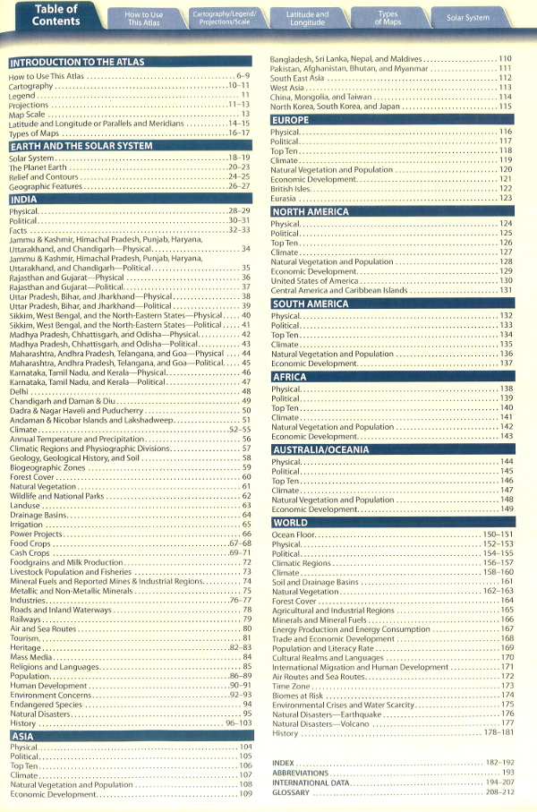
The revised edition of BSure School Atlas is encyclopedic reference book that deals with history, geography, wildlife, climate, population, agriculture, industries, tourism, and more. From the fundamentals of map reading to extensive coverage of topical issues, the atlas is a handy guide for students and researches alike. it is highly relevant to today’s school curriculum as it helps students get a wider perspective on the world around them. Smart design, clear cartography, nuggets of information, and stunning images make it a top-of-the-line book.
Features
- Includes a through introduction to how to locate places, measure distances, and find directions of maps
- Gives an easy to understand introduction to map symbol, legends, and projections
- Introduces the history of earth with pages on the solar system, the realms of earth, landforms and other similar themes
- Covers more than 100 thematic maps of India and 44 thematic world maps
- Includes data profile of all status and UTs of India along with their political and physical maps
- Includes political, physical and thematic maps of every continent along with maps of important countries
- Includes world maps depicting environmental crises, economic issues, and developmental challenges
- Contains latest statistics gathered from authentic sources such as Census of India and Central Statistical Organisation
- Includes flags of 194 countries accompanied by explanatory notes and fast facts
- Provides crisp write-ups for a better understanding of maps
- Includes bar graphs and pie charts for visual representation of map-related data
- Provides 3-D relief maps and distinct page marking for each section for better readability
- Includes clearly printed topographic sheets as pull outs to help students prepare for board exams
- Includes a section of top 10 countries based on area, life expectancy, population density, and per capita income for each continent

Reviews
There are no reviews yet.